
In 2024, there will be four eclipses: two solar eclipses and two lunar eclipses
| Date | Type | Visibility |
| 25 March 2024 | Penumbral lunar eclipse | Partially visible in Belgium |
| 8 April 2024 | Total solar eclipse | Invisible in Belgium |
| 18 September 2024 | Partial lunar eclipse | Visible in Belgium |
| 2 October 2024 | Annular solar eclipse | Invisible in Belgium |
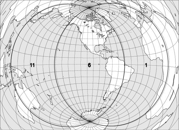
I – 25 March 2024 – Penumbral lunar eclipse, partially visible in Belgium
| Phase | Universal Time | Longitude | Latitude | Position angle | Altitude at Uccle/Ukkel |
| Penumbral eclipse begins | 04h51,0 | 071 45 W | 00 38 S | 161 E | +07 |
| Moonset at Uccle/Ukkel | 05h38,0 | 083 12 W | 00 50 S | 172 E | 0 |
| Maximum of the eclipse | 07h12,9 | 106 17 W | 01 12 S | 209 E | – |
| >Penumbral eclipse ends | 09h34,7 | 140 49 W | 01 46 S | 257 E | – |
The longitude and the latitude refer to the point on Earth where the Moon is at that time at its zenith. The position angle is defined from the imaginary line that connects the center of the lunar disc to the center of the Earth’s shadow. It is measured at the center of the lunar disc, from the North, in an anti-clockwise direction. At the beginning and at the end of the penumbra and shadow phases, it is the position angle of the contact point. The altitude and times of the Moon’s rise and fall are calculated for its center, without taking refraction into account.
Magnitude of the eclipse: 0.982, the diameter of the lunar disk being taken as the unit.
The map below shows the region where the eclipse is observable. The explanation of the codes used can be found at the bottom of the page.
II – 8 April 2024 – Total solar eclipse, invisible in Belgium
| Phase | Universal time | Longitude | Latitude |
| Eclipse begins | 15h42,2 | 143 23 W | 14 58 S |
| Total eclipse begins | 16h38,8 | 157 57 W | 08 01 S |
| Central eclipse begins | 16h40,0 | 158 32 W | 07 50 S |
| Maximum of the eclipse | 18h15,3 | 104 42 W | 24 42 N |
| Central eclipse at local apparent noon | 18h36,1 | 098 38 W | 30 37 N |
| End of the central eclipse | 19h54,5 | 019 48 W | 47 37 N |
| End of the total eclipse | 19h55,6 | 020 32 W | 47 27 N |
| End of the eclipse | 20h52,3 | 035 47 W | 40 26 N |
The map below shows the region where the eclipse is observable. The explanation of the codes used can be found at the bottom of the page.
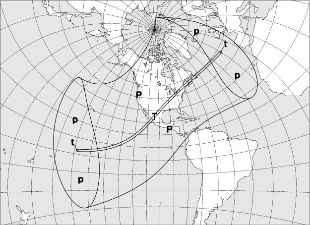
The duration of the totality phase along the centrality line will reach a maximum of 4m 32s at a point located at 103° of longitude west and 26° of latitude north.
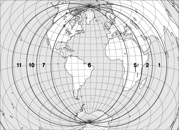
III – 18 September 2024 – Partial lunar eclipse, visible in Belgium
| Phase | Universal Time | Longitude | Latitude | Position angle | Altitude at Uccle/Ukkel |
| Penumbral eclipse begins | 00h39,3 | 011 54 W | 03 13 S | 022 E | +33 |
| Partial eclipse begins | 02h11,8 | 034 14 W | 02 45 S | 349 E | +26 |
| Maximum of the eclipse | 02h44,3 | 042 04 W | 02 35 S | 331 E | +23 |
| Partial eclipse ends | 03h16,8 | 049 54 W | 02 26 S | 313 E | +19 |
| Penumbral eclipse ends | 04h49,2 | 072 13 W | 01 57 S | 280 E | +06 |
The longitude and the latitude refer to the point on Earth where the Moon is at that time at its zenith. The position angle is defined from the imaginary line that connects the center of the lunar disc to the center of the Earth’s shadow. It is measured at the center of the lunar disc, from the North, in an anti-clockwise direction. At the beginning and at the end of the penumbra and shadow phases, it is the position angle of the contact point. The altitude and times of the Moon’s rise and fall are calculated for its center, without taking refraction into account.
Magnitude of the eclipse: 0.091, the diameter of the lunar disk being taken as the unit.
The map below shows the region where the eclipse is observable. The explanation of the codes used can be found at the bottom of the page.
IV – 2 October 2024 – Annular solar eclipse, invisible in Belgium
| Phase | Universal time | Longitude | Latitude |
| Eclipse begins | 15h43,0 | 147 36 W | 16 01 N |
| Annular eclipse begins | 16h50,6 | 165 02 W | 8 54 N |
| Central eclipse begins | 16h53,6 | 165 33 W | 08 23 N |
| Maximum of the eclipse | 18h44,8 | 114 33 W | 21 54 S |
| Central eclipse at the local apparent noon | 19h08,1 | 109 45 W | 27 48 S |
| End of the central eclipse | 20h36,2 | 037 05 W | 49 29 S |
| End of the annular eclipse | 20h39,2 | 037 31 W | 48 57 S |
| Fin de l’éclipse | 21h47,0 | 055 31 W | 41 46 S |
Maximum size of the eclipse: 0.933, the diameter of the solar disc being taken as the unit.
The map below shows the region where the eclipse is observable. The explanation of the codes used can be found at the bottom of the page.
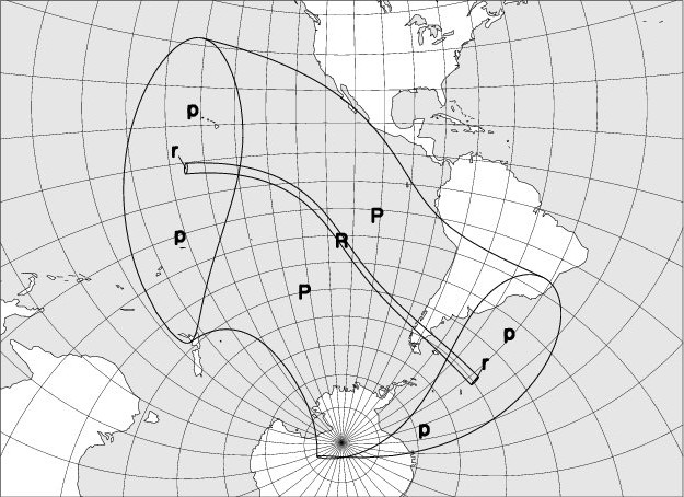
The duration of the annular phase along the centrality line will reach a maximum of 7m 20s at a point located at 113° of longitude west and 24° of latitude south.
Explanations:
The codes used on the maps to indicate the moon eclipse visibility are: entry into the darkness is visible in regions 1 to 6, entry into the darkness in regions 2 to 7, the beginning of the totality in regions 3 to 8. The exits of the totality, the shadow and the penumbra are respectively observable in regions 4 to 9, 5 to 10, and 6 to 11. In region 6, the entire eclipse can be observed, in regions 5 to 7 the umbral phases are observable; in regions 4 to 8 the totality is fully visible.
On solar eclipse visibility maps, the following codes are used:
“P”: Partial eclipse of the Sun, visible.
“p”: Partial eclipse of the Sun, partly visible.
“R”: Annular eclipse, whose annular phase is fully observable.
“r”: Annular eclipse, whose annular phase is partially observable.
“T”: Total eclipse, whose totality phase is fully observable.
“t”: Total eclipse, whose totality phase is partially observable.
The basic data used to write the eclipse chapter were borrowed from the DE405 digital integration, kindly provided by the Jet Propulsion Laboratory. To move from Terrestrial Time (TT) to Universal Time (UT), the following provisional relationship was used:
UT = TT – 69.0 s